Climate & Snow in North America
North America has a continental climate. This means the climate is generally dry, with cold winters and hot summers, but with the wide variation that is to be expected over a continent extending from the Arctic Circle to the tropics.
This variation is only partly due to the range of latitude the continent spans. The overall shape and elevation also influence the climate. Although large, North America is compact. The only extensive areas of open water are Hudson Bay and the Great Lakes. There are no deep indentations along the western coast. The western mountain ranges run north-to-south, thus forming an effective barrier to weather systems moving from west to east. To the east of these mountains the land slopes very gradually to the Great Plains. Dodge City, Kansas, equidistant between the Pacific and Atlantic, is still 2,594 feet (791 m) above sea level. Temperature decreases with height, making the western side of North America cooler than it would be were its elevation lower.
Air Flows
The North American climate is produced by the type of air that crosses it. Cold, dry, conti-nental polar air lies over northern Canada and sometimes moves south in winter, producing cold waves that reach almost as far as the Gulf of Mexico. Hot, dry continental air lies over Mexico. It tends to move north in summer. Cool, moist maritime polar air enters the continent from both the Atlantic and Pacific. The Atlantic air enters over Labrador and moves south as far as Maine. Pacific air crosses the Rocky Mountains, losing most of its moisture on the western side of the range and producing dry conditions over the Great Plains. Maritime tropical air from the Gulf and Pacific brings warm, moist conditions to the Gulf states and to southern California in winter.
The interior of the continent cools fairly rapidly during the autumn. This chills the air, increasing its density and causing it to subside. Consequently, a large area of high pressure forms, centered approximately over Utah. High pressure also forms over northwestern Canada. Pressure is low over the Aleutian Islands and in the northeast. Air circulating counterclockwise around the low-pressure center in the northwest and clockwise around the high-pressure center further south drives weather systems across the continent. There are many depressions, capable of delivering heavy snow and moving quite fast along a generally easterly or northeasterly track. The depressions alternate with high-pressure systems (anticyclones) that bring clear skies and low temperatures.
Temperature and the Chinook Effect
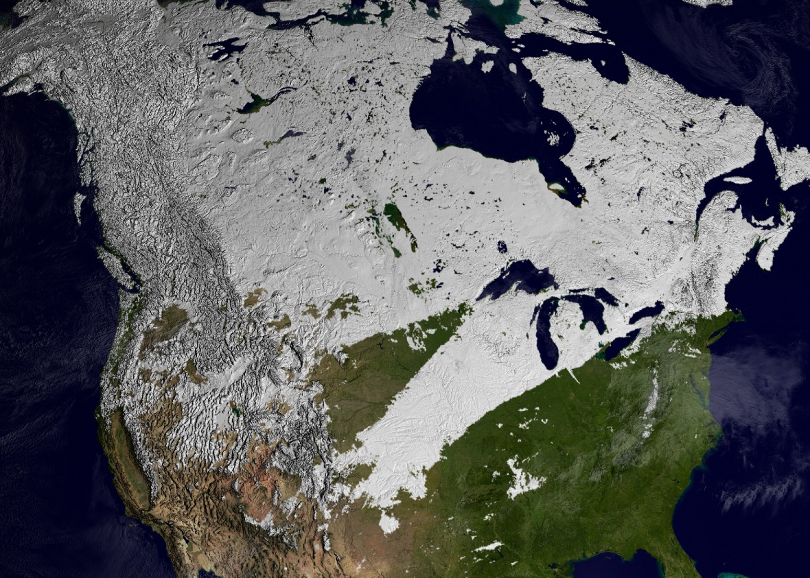
Obviously, the average temperature must remain below freezing in order for snow to fall and then remain on the ground. In January, the mean temperature is cold enough for snow over the whole of Canada, except for the coastal fringe of British Columbia, and in the northwestern and northeastern United States and in the central part of the continent to about the latitude of Omaha, Nebraska.
Snow tends not to survive the winter immediately to the east of the Rocky Mountains. This is due in part to the fact that the climate is dry. Calgary, Alberta, for example, receives an average of only 2.3 inches (5.9 cm) of rain over the four months from November to February. It is also due to the chinook winds that from time to time bring dry, much warmer air down from the mountains. The effect is so dramatic that the chinook is sometimes called the “snow eater.”
The chinook (named after the Native American people who once lived along the lower reaches of the Columbia River) occurs when stable air is lifted over the Rocky and Cascade Mountains. The air subsides on the lee side of the mountains, warming by compression as it does so. It brings winds that sometimes gust to 100 mph (160 kph), but more significantly it rapidly raises the temperature. A chinook has been known to raise the temperature from -4°F (-20°C) to 45°F (7°C) in two minutes, and a rise of 40°F (22°C) in 15 minutes is quite common. A chinook can clear snow faster than a snowplow!

North America Chinook Effect © Live Science
The Lake Effect
There are ski resorts in almost every state and province that have mountains. Obviously, most of the best skiing is to be found in the Rocky Mountains, especially in Colorado, which has the highest peaks and therefore abundant snow despite the state’s semi-arid climate. The heaviest snowfalls are often not there, however, but in the northeastern United States and Appalachian Mountains. This is “lake effect” snow and it provides excellent conditions for winter sports.
During the autumn, large bodies of water cool down much more slowly than does the surrounding land. Even at the end of winter, when the lakes have cooled, the water is still much warmer than the land and the lakes do not freeze over. It is in late autumn and early winter, however, that the difference in temperature between the land and the surface water of the lakes is most marked, and that is when the heaviest snowstorms occur-notoriously, around Thanksgiving.
Cold, dry air crosses the continent from the west. When it crosses the lakes, contact with the relatively warm water raises the temperature of the lowest layer of air, and because the air is then warmer, large amounts of water evaporate into it. The warm air rises in discrete amounts, like huge bubbles, and mixes with the overlying colder air. This moistens the upper air and the moistened layer becomes progressively deeper as the air continues across the lakes. Some of the moisture soon condenses again to form steam fog on the water surface, and some condenses near the top of the mixed layer to form stratocumulus cloud. More than half of the moisture mixes into the air beyond the lakes.
Droplets in the stratocumulus cloud start to freeze, and snowflakes begin to develop. These drift with the cloud to the downwind shore. Beneath the cloud, the moist, warm air crosses the land beyond the lakes, but when it reaches the hills to the east of the lakes and is forced to rise, its moisture condenses, snowflakes form, and there is a snowstorm.
The average annual snowfall to the east of the Great Lakes is up to three times greater than that in the same latitude to the west. North Dakota usually expects about 40 inches (1 m) of snow during the winter. Parts of New England, the Adirondacks, and the eastern Appalachians, however receive 130 inches (3.3 m.) The heaviest snowfalls occur in areas known as “snowbelts,” up to about 50 miles (80 km) to the east of the Great Lakes. Look for good snow in Wisconsin, Michigan, Pennsylvania, New York, and the Adirondack and Appalachian Mountains, but of course skiers need good mountainous terrain and not all of these states are ideal for skiing.

North America Snowcover Winter


